Maps versus Hands
Or, if you prefer, Tom Barnett versus J Smith. In the comments to this post below, regular A9 commenter J Smith hits on something I've thought about for awhile... haven't we seen all this before?
While Smith doesn't take his argument as a foil for Barnett's "New Map", I think the argument serves well in that mold.
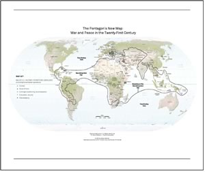
That is Barnett's now famous "New Map" using a "core" and "gap" dichotomy to describe the current security of the world (clicking will take you to a low res pdf version). The "Core" is made up of mostly Western or western-like liberal democracies with a free market economy. The "gap" is made up of mostly third world countries. Smith, in the comments mentioned, reduces this to a more simplistic dichotomy: first world versus third world.

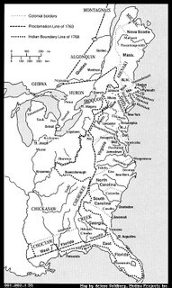
The above is a map of colonial N. America circa 1770 (click to see an enlarged view, where you may zoom in with another click). Note the Proclamation Line of 1763 and the eventual Indian Territory border of 1768. Note also the dots of major port cities: the "core" of the colonies if you will. Recall now that Vermont was the first new entrant into the "core", in 1791. Looking at the map above it is easy to see why. For about three decades, the borders of Vermont and the "gap", or Indian territory, had been very well defined.
Looking South one sees why it took so long to get Mississippi and Alabama admitted... they were deep inside the "gap". Indeed, E. Louisiana became part of the "core" before these two areas did. It would require the wholesale liquidation of the Cherokee, the slaughter of the Creek, and the destruction of the Choctaw to make those states "settled", all of which weren't complete until well after the turn of the century.
Barnett and other globalization theorists talk about "soft kills" and "integrating" the gap countries into the "core". But we did that already, here, in America. It wasn't soft either. About the softest "kill" was the legendary purchase of Manhattan; now known to be mostly myth. But that was the exception. For two hundred years, the rule was wholesale slaughter of men, women and children. It isn't pretty. It isn't made for TV. Here is a reminder:
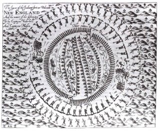
 That may look like a nice picture, but if you study it carefully (click to enlarge) you'll see it depicts British soldiers surrounding a village of innocent Indians, with torches lit. The whole village was lit up in flames. This innocent picture depicts this horrible story:
Smith chastizes the theorists for not realizing the implications of their theory. And I happen to think Smith is right. None of these theorists wants to face the horror of the reality of their ideas. This is the difference between those that use maps, and those that use their hands. The practical implication of Barnett's thesis, if it is to be successful, is the colonization of much of the third world.
And the practical implication of colonizing the third world is that America will need to once again be "ok" with burning villages, slaughtering women and children, and doing it all at night with no pretext. I don't think the American people have the stomach for that... if you doubt it, just look at what American theorists have the stomach to "draw".
While Smith doesn't take his argument as a foil for Barnett's "New Map", I think the argument serves well in that mold.

That is Barnett's now famous "New Map" using a "core" and "gap" dichotomy to describe the current security of the world (clicking will take you to a low res pdf version). The "Core" is made up of mostly Western or western-like liberal democracies with a free market economy. The "gap" is made up of mostly third world countries. Smith, in the comments mentioned, reduces this to a more simplistic dichotomy: first world versus third world.

The above is a map of colonial N. America circa 1770 (click to see an enlarged view, where you may zoom in with another click). Note the Proclamation Line of 1763 and the eventual Indian Territory border of 1768. Note also the dots of major port cities: the "core" of the colonies if you will. Recall now that Vermont was the first new entrant into the "core", in 1791. Looking at the map above it is easy to see why. For about three decades, the borders of Vermont and the "gap", or Indian territory, had been very well defined.
Looking South one sees why it took so long to get Mississippi and Alabama admitted... they were deep inside the "gap". Indeed, E. Louisiana became part of the "core" before these two areas did. It would require the wholesale liquidation of the Cherokee, the slaughter of the Creek, and the destruction of the Choctaw to make those states "settled", all of which weren't complete until well after the turn of the century.
Barnett and other globalization theorists talk about "soft kills" and "integrating" the gap countries into the "core". But we did that already, here, in America. It wasn't soft either. About the softest "kill" was the legendary purchase of Manhattan; now known to be mostly myth. But that was the exception. For two hundred years, the rule was wholesale slaughter of men, women and children. It isn't pretty. It isn't made for TV. Here is a reminder:
 That may look like a nice picture, but if you study it carefully (click to enlarge) you'll see it depicts British soldiers surrounding a village of innocent Indians, with torches lit. The whole village was lit up in flames. This innocent picture depicts this horrible story:
the burning of the fortified Pequot village on the Mystic River in 1637, by English soldiers and their Narragansett and Mohegannative allies. They surprised the sleeping village of several hundred, burned the village to the ground and killed the fleeing natives. Neither women nor children were spared in the massacre. Native allies who had not already fled (not really having the stomach for war) were horrified at the English savagery. Captain John Underhill, who led the slaughter, would later find justification for killing those women and children by citing Kind David's Old Testament genocidal slaughters.That was the rule. Underhill later perfected this strategy and used it up and down the Northeastern coast. America later perfects this strategy again, and uses it to great effect in the battles for the plains and the West.
Smith chastizes the theorists for not realizing the implications of their theory. And I happen to think Smith is right. None of these theorists wants to face the horror of the reality of their ideas. This is the difference between those that use maps, and those that use their hands. The practical implication of Barnett's thesis, if it is to be successful, is the colonization of much of the third world.
And the practical implication of colonizing the third world is that America will need to once again be "ok" with burning villages, slaughtering women and children, and doing it all at night with no pretext. I don't think the American people have the stomach for that... if you doubt it, just look at what American theorists have the stomach to "draw".

